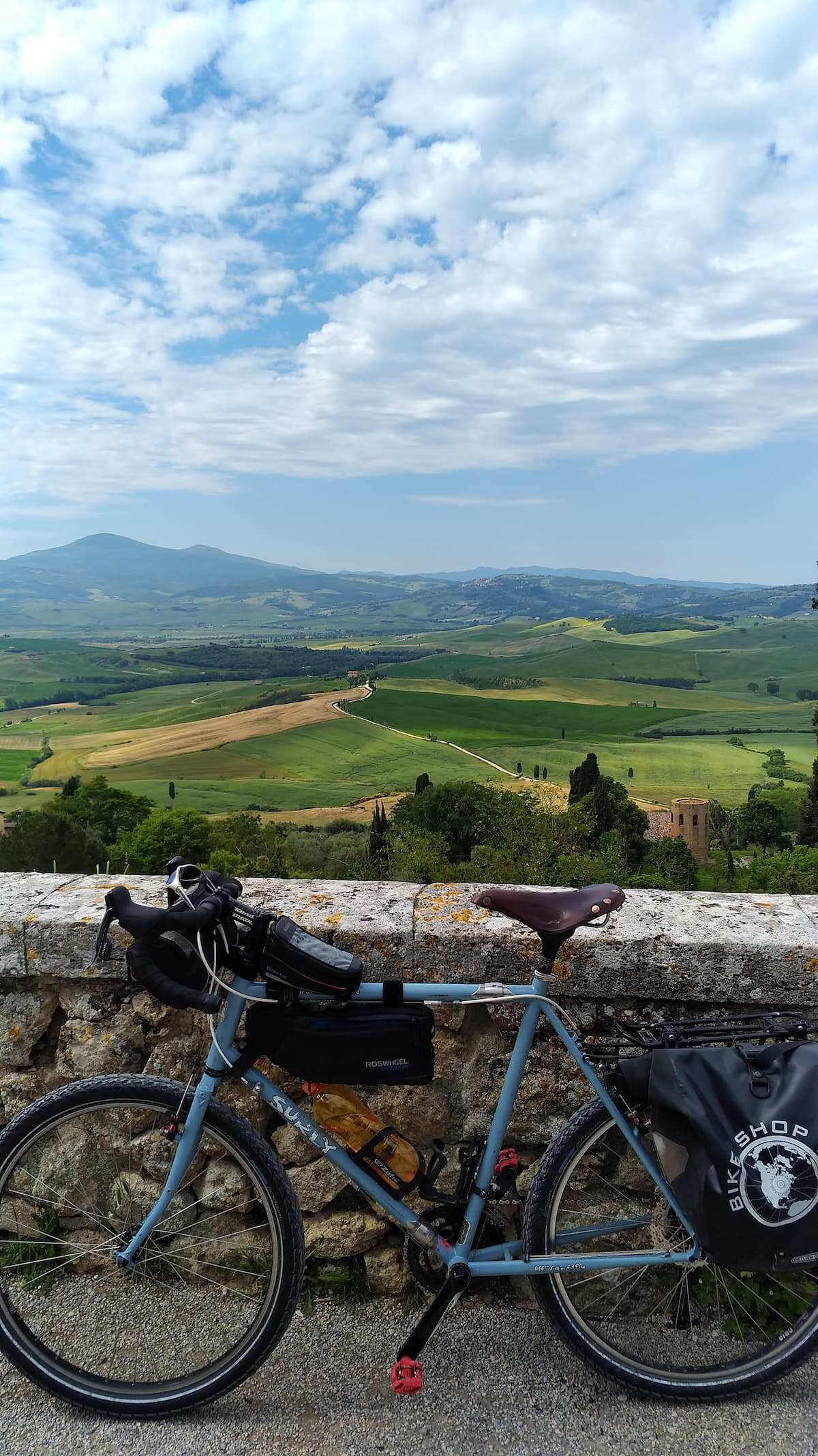
There is a problem with Tuscany. Almost everyone already knows what it looks like. Long before arriving, we have seen the cypress-lined roads, vineyards rolling across hills, ochre farmhouses, medieval towns perched above valleys, Renaissance churches and fields splashed with red poppies. Tuscany appears on calendars, wine labels, postcards and travel advertisements so often that the landscape can seem familiar before we have ever set foot in it.
The problem with the postcard, however, is that it is flat. Travel through Tuscany by bicycle and suddenly those beautiful rolling hills have gradients. The medieval town sitting so perfectly above the valley has to be climbed to. The white gravel road disappearing between cypress trees rattles beneath your tires. The vineyard-covered descent that seems effortless in a photograph carries an unavoidable implication: sooner or later, you are going to have to climb again. And strangely, none of that diminishes the postcard. It explains it.
That was what I discovered during six weeks cycling through Tuscany and neighboring Umbria. I could have covered the route much faster. But what would have been the point? I wanted time to stop for photographs, an espresso or a glass of wine whenever I felt like it, to establish myself for several days in certain places and ride out in different directions rather than simply race from one overnight stop to another. The bicycle turned out to be an ideal way of discovering an Italy that is extraordinarily beautiful precisely because it refuses to be hurried.
Florence: Where the Hills Begin
Florence was my starting point. It would be easy to spend days there without ever thinking about cycling beyond the historic center. The Arno, Ponte Vecchio, Piazza del Duomo, Santa Croce, Palazzo Vecchio—the city contains enough art and architecture to overwhelm almost anyone. Yet one advantage of having a bicycle is that a city quickly becomes geographical rather than merely monumental. I learned my way around Florence partly through an accident: I had arrived without my pedals and spent my first excursion looking for a bicycle shop that could supply pedals compatible with my cycling shoes. By the time I succeeded, several shops later, I had inadvertently learned my bearings. Florence itself was surprisingly agreeable to cycle. Locals rode everywhere—commuters, shoppers, road cyclists—and the Arno provided an obvious axis through the city.
But the real preparation for Tuscany came just beyond the center. The climb to Fiesole rises from below 50 meters to around 300 meters above sea level in only a few kilometers. I regarded it less as sightseeing than as training. The hills had begun.
Chianti: The Postcard Comes Alive
Cycling south from Florence, one obvious direction is Chianti. There is a reason local cyclists head toward Greve, Radda and Gaiole. Within a couple of hours, urban Florence gives way to precisely the Tuscany that has been reproduced so endlessly: olive groves, vineyards, stone houses, wooded ridges and roads curling over hills. My first base was Cavriglia, where I stayed in a small house on a hillside among olive trees. That in itself changed the rhythm of the journey. Instead of riding relentlessly onward every morning, I could leave most of my belongings behind and explore. Radda lay over a ridge. Gaiole in another direction. Wineries appeared along roads that alternated between beautifully paved surfaces and the unpaved gravel for which this part of Tuscany has become famous.
The road to Radda involved two substantial climbs. Rain followed me much of the way, and by the time I returned I wanted little more than a glass of red wine and a fire in the stove. It was not postcard weather. But that too became part of Tuscany. Then came Gaiole.
L’Eroica and the Roads That Remember
Gaiole occupies a special place in cycling culture because of L’Eroica, the celebrated vintage cycling event that begins and ends there. There is something wonderfully appropriate about L’Eroica taking place in Tuscany. Modern cycling increasingly revolves around technology—lighter frames, electronic shifting, aerodynamic equipment, data displayed continuously on screens. L’Eroica looks backward instead: vintage bicycles, traditional clothing and the old gravel roads, the strade bianche, that once simply were roads. I wasn’t there during the event, but its presence was everywhere.
From Gaiole I climbed toward Castello di Brolio in miserable weather. Rain forced me beneath trees and eventually into shelter in Gaiole itself. Then, almost theatrically, the fog began to lift. Sunlight appeared. Beyond Brolio I picked up the L’Eroica route. What followed was one of those rides that explains why cyclists become irrationally enthusiastic about Tuscany. The road dropped through an undulating green landscape of vineyards, tiny hamlets and sweeping views toward Siena. Even when rain began again, it hardly mattered. The scenery had become so overwhelmingly Tuscan that weather had lost the argument. Eventually the descent ended. Naturally, Siena was above me. There was another climb.
Hill Towns Are Different From Below
Siena made something obvious that would repeat itself throughout the journey. Italy’s hill towns were built where they were for reasons that had nothing to do with modern tourists wanting a pretty view. Defense mattered. Visibility mattered. Control of the surrounding countryside mattered. The bicycle makes you understand this immediately. A car largely erases topography. Press the accelerator and the hill town appears. On a bicycle, you see it above you and think: I have to get up there. Then you climb.
Siena rewards the effort extravagantly. Piazza del Campo spills downward toward Palazzo Pubblico and Torre del Mangia, a medieval urban space unlike almost any other. The same piazza that hosts the Palio horse race is also the finishing point of Strade Bianche, another reminder that cycling is woven deeply into this landscape.
But eventually the bicycle pulls you onward. South of Siena lies Val d’Orcia. And here the Tuscany of imagination becomes almost absurdly real.
Into Val d’Orcia
The landscape south of Siena seems designed by someone who understood composition. Cypress rows crest hills. Farm roads curve toward solitary houses. Poppies punctuate green fields. Towns appear on ridges exactly where a painter would have put them. Yet again, the bicycle supplies the missing dimension. From Siena I descended toward the Arbia River valley and Buonconvento, the gateway into Val d’Orcia. Rather than follow the easiest road directly toward San Quirico, I took the higher route below Montalcino. Why? Because other cyclists were turning that way. That is often sufficient reason. The road climbed for kilometers, but from the ridge the views opened across Val d’Orcia. San Quirico itself turned out to be an ideal base—a quiet, unpretentious town that for centuries has stood along the Via Francigena pilgrimage route. From there the bicycle could go in almost any direction and find something remarkable. One direction led upward. Toward Montalcino.
You Have to Earn Montalcino
Montalcino announces itself long before you arrive. The town dominates a ridge more than 500 meters above sea level, visible from the surrounding countryside as though daring the cyclist to come up. I had already climbed near it once while traveling south from Siena. Then I went back and deliberately climbed it again. That may sound irrational to anyone who doesn’t enjoy cycling hills. But Montalcino is exactly the kind of place that turns climbing into part of the experience. As altitude increases, the surrounding landscape expands. The views east become more dramatic. Then you reach the ridge, enter narrow streets and suddenly the valley that seemed enormous from below lies beneath you. This is what the postcard cannot communicate. The view isn’t merely something you see. It is the reward for getting there. And then, of course, comes the descent.
The White Road to Pienza
Another ride from San Quirico took me onto one of L’Eroica’s gravel roads toward Pienza. This may have been Tuscany distilled into a single morning. The dusty road was virtually empty. It wound past isolated estates and tiny settlements while Val d’Orcia opened around it. Red poppies appeared beside the road. Cypress groves punctuated the ridges. Solitary roadside crosses stood against the landscape. The road itself mattered. This wasn’t a smooth highway providing access to scenic places. The road was part of the scenery and part of the experience—white gravel beneath the tires, winding through the same landscape it allowed me to see. Eventually I reached Pienza.
The Renaissance town is beautiful, but once again it was the view outward that stayed with me most strongly: Val d’Orcia rolling away beneath the town. Then I coasted back down into the valley. The entire ride was only about 34 kilometers. It became one of the most memorable of the journey. Mileage is a poor way to measure certain days.
When Tuscany Stops Looking Like Tuscany
After Pienza, I thought it would be difficult for another stage to surpass it. Then I rode toward Pitigliano. The route immediately disrupted the comfortable visual idea of Tuscany. A gravel road climbed through Val d’Orcia toward Rocca d’Orcia. The landscape became steeper and more muscular. One incline was marked at 20 percent, though pushing my loaded bicycle up it, I suspected somebody had been feeling charitable when they painted the sign. E-bikes sailed past. I pushed. The road eventually climbed into the Monte Amiata range, through woods and past a ski area, before dropping toward southwestern Tuscany. This was no longer the soft Chianti landscape.
And then, late in the day, Pitigliano appeared. For kilometers I hadn’t been able to see it. I rounded one final bend and suddenly the town towered above the road like a mirage. Built on a tufa cliff, Pitigliano seems almost to grow directly from the rock beneath it. Nearby Sorano and Sovana reinforced the sense that I had entered another Italy—still Tuscany, but far removed from the familiar imagery of Chianti. Roads were carved through tufa; medieval streets occupied improbable ridges; fortresses dominated valleys. This was Tuscany beyond its own postcard. And beyond Pitigliano, my route turned east. Toward Umbria.
Umbria: The Neighbor in Tuscany’s Shadow
Tuscany may be one of the world’s great travel brands. Umbria is not. That can be an advantage. Crossing through Lazio toward Orvieto, the landscape remained unmistakably central Italian, but the cultural gravity subtly shifted. Tuscany’s famous wine towns and internationally recognizable imagery gave way to places that seemed less concerned with being observed. Then Orvieto appeared. Like Pitigliano, it seemed almost geologically inseparable from its setting—an entire city lifted above the valley on steep cliffs. Naturally, there was a climb. My first attempt was up an 11-percent road that rises brutally from below the town. I later discovered a more civilized access route. Yet over several days I climbed to Orvieto four times. Once above the cliffs, the experience changes completely. Corso Cavour runs through the old town; narrow streets branch away; the Duomo and Torre del Moro become orientation points. Soon the intimidating hilltop city becomes somewhere you casually ride around. That transformation fascinated me. The town initially exists as an obstacle above you. Then you climb into it. A day later it feels like a neighborhood.
Todi, Spoleto and the Other Rhythm of Umbria
South and east of Orvieto, Umbria continued in a succession of hills, valleys and towns mounted improbably above them. Todi dominated the skyline as I rode around Lake Corbara and climbed beyond it. Even after passing the town, I kept looking back and seeing it clinging to the hillside. Then eventually Todi disappeared behind a wooded ridge. Ahead, Spoleto appeared. The Rocca Albornoziana crowned the town like a fortress placed deliberately to ensure nobody approaching could miss it. But one of the nicest surprises came after Spoleto. The riding suddenly relaxed. Instead of repeated strenuous climbs, the route toward Assisi followed dedicated bicycle paths and sleepy farm roads through a broad valley. Much of the surface was unpaved but easy. Poppies grew so enthusiastically along sections of the path that they narrowed it almost to singletrack. Hill towns lined the ridges on either side. Bevagna appeared with its maze of streets. Then, farther ahead, Assisi rose into view. Again: there it was. Above me.
Assisi and the Geometry of Pilgrimage
Assisi is one of those places whose name is known long before its geography. Saint Francis made the town universal. The bicycle made it physical. From Santa Maria degli Angeli below, the route climbs steeply toward Porta San Francesco and the Basilica. The gradients reach roughly 14 percent in places. Once inside the town, the streets settle somewhat, carrying you through an extraordinary sequence of medieval buildings, piazzas and churches beneath Rocca Maggiore. Pilgrims have approached Assisi for centuries. I was merely doing it with gears. But the relationship between effort, arrival and place is perhaps not entirely different. A destination positioned on a hill acquires meaning as you approach it slowly. You have time to see it. Time to anticipate it. And enough time climbing toward it to wonder why nobody built it in the valley.
Lake Trasimeno and Back Toward Tuscany
Eventually the circuit began bending north and west. Past Perugia came Lake Trasimeno. After all the famous names—Florence, Siena, Montalcino, Assisi—the lake offered another form of Italy: gently rolling highlands leading toward water, small towns and views opening from the hills around Magione before descending toward the lakeshore. At Tuoro sul Trasimeno the landscape also carries much older memories. It was near here in 217 BC that Hannibal inflicted one of Rome’s great defeats during the Second Punic War. Travel by bicycle does this repeatedly in Italy. The physical landscape and historical landscape overlap. You ride through something beautiful and discover armies once crossed it, pilgrims followed it, medieval cities fought over it, Renaissance patrons transformed it, professional cyclists now race across it. The road is rarely only a road. Then came Cortona, Arezzo and the gradual return toward Chianti. The circle was closing.
Back Into the Postcard
My final major stage carried me through Radda and Panzano again. By then I knew the hills. There were cyclists everywhere around Panzano, which hardly surprised me. The road climbed above 700 meters on the way toward Radda, rose again toward Panzano and then gradually surrendered altitude through Greve toward Florence. At Greve the piazza was busy with day-trippers. I circled it and continued north. Near Greti I stopped for one last look back into Chianti. Then came a final gentle rise to Spedaluzzo. From the crest, Florence lay ahead. I pushed off and freewheeled toward the city. Six weeks after leaving it, I was completing a circle.
Why Tuscany and Umbria Work So Well by Bicycle
I rode close to 1,300 kilometers during that journey, although the principal point-to-point stages linking my bases added up to only about 630 kilometers. The difference matters. Much of the best riding consisted of loops and excursions—Montalcino from San Quirico, Pienza, Sorano and Sovana, Assisi, the hills around Chianti—rides taken because there was something worth exploring rather than because I needed to reach another hotel. That may be the best way to think about cycling Tuscany and Umbria. Don’t treat them merely as territory to cross. Choose a town. Stay awhile. Ride out in one direction today and another tomorrow. Climb because something interesting is above you. Follow a gravel road because it looks inviting. Stop because the view is better than expected. Have an espresso because there is no compelling reason not to. There will always be another hill. There will also be another descent. And another town waiting on the ridge.
Tuscany deserves its fame. The vineyards, cypress roads, Renaissance cities and Val d’Orcia really are as beautiful as the photographs promise. But the bicycle reveals something the photographs cannot. It restores dimension to the landscape. You feel the distance between Florence and Siena, the height of Montalcino, the roughness of an L’Eroica gravel road and the relief of cresting a ridge. You discover southwestern Tuscany where the familiar imagery gives way to mountain roads and tufa towns. And crossing into Umbria, you find a quieter neighbor filled with its own remarkable hill towns, valleys, pilgrimage routes and roads worth following simply to see where they go. You could travel faster. You could see more. But why?
The postcard shows you Tuscany and Umbria.
The bicycle lets you enter the picture.
Planning to explore the region by bicycle? My downloadable Cycling Tuscany & Umbria guide follows the route through Chianti, Siena, Val d’Orcia, southwestern Tuscany and Umbria, with stage details, accommodations and GPX tracks.